


Guilford — Ten days before the one-year anniversary of storm Sandy’s sweep through the coastal flanks of this shoreline community, town planner George Kral surveys an area that took one of the storm’s hardest hits -– Seaside Avenue.
“The road was totally inundated,” he recounted. “All of the houses had water in their basements for sure or up into the first floor depending on the exact elevation of the road.”
Appropriate to its name, on this sunny, if chilly, Friday afternoon, Seaside Avenue offers an array of vistas of Long Island Sound as the road transects what in earlier times was a seaside salt marsh.
“We’re standing at a low point in the road,” Kral said. “You can see the marshes and the marsh grass coming right up to the edge of the pavement, literally. The drainage culvert right there to our right is the low point and this area floods frequently.”
That means not just in storms like Sandy or Tropical Storm Irene the year before, but in recent years during more common nor’easters, rainstorms and regularly with astronomical high tides.
The environmental reality of that, along with projected sea level rise for the indefinite future, places many of Guilford’s coastal areas in the same kind of ongoing jeopardy Seaside Avenue has faced. And for that reason Guilford, with Kral leading the charge, is taking an action no other town or city in the state has.
It has put together a blueprint that peers far, far into the future to envision what the town ought to look like physically in the face of a changing climate. That blueprint, known as the Community Coastal Resilience Plan, offers radical solutions -– ones public officials generally are loath to propose.
The Seaside Avenue neighborhood, for example, could pretty much cease to exist.
A new geography
“These sea level rise issues are long-term,” Kral said. “And it gives us the opportunity, assuming we take the opportunity, to plan for a new type of coastline, a new geography, a new type of community.”
The plan’s inception was actually before Irene as the effects of climate change and sea level rise -– more frequent flooding, expanding salt marshes — were becoming more and more apparent. But the storms over the two years that followed help focus community attention through a series of public input sessions.
The plan that emerged lays out areas of town and the risks they share to housing, structures, roads, wastewater and fresh water facilities and more. It offers suggestions, recommendations, scenarios and even full-bore schematics for how to cope with all of the above. It also steps away from classic concepts of protection, retreat and accommodation.
There are cases where it suggests a traditional step — elevating roads. Old Quarry Road is due to be raised next spring to maintain more reliable access to homes at the far end of a salt marsh that intersects it. And it advocates working with the state and the neighboring town of Branford to elevate many spots along state Route 146 that are inundated even during very high tides. 
But mostly it offers new models, including returning some areas to nature, allowing Guilford’s snaking and abundant salt marshes to migrate unimpeded, and finding new locations for those displaced — all while trying to keep the town’s considerable shoreline property tax base from vanishing and with it, a needed source of revenue.
It contemplates unique wastewater and water systems. For instance instead of septic systems, which is what Guilford has, it suggests group collection points on higher ground and pumping systems for them as well as methods such as on-site composting.
Floating housing
It floats, somewhat literally, the notion that areas of town might only be accessible by water and that some housing could wind up on boats.
“Guilford is the community that’s farthest out ahead in the state of Connecticut by far,” said Adam Whelchel, director of science at the Nature Conservancy in Connecticut, which worked with Guilford on the plan, and has helped two dozen other communities around the state on mitigation issues. His view is widely shared among environmental officials. He and others think Guilford eventually could be a model for other municipalities and regions.
The Conservancy used its coastal resilience mapping tool to help Guilford predict how its salt marshes would migrate through this century and the town’s vulnerability in various storm and sea level rise scenarios.
“If we consider this issue now, we will have more flexibility in the future with the decisions that we have to make, and potentially we could avoid future costs,” Whelchel said. He noted that every dollar spent on mitigation saves taxpayers $4, that early mitigation will help avoid costly and repetitive repairs after every storm, and that it better positions a community to take advantage of funding opportunities.
“But you have to remember that some of these coastal towns have been making decisions of where things go and why for over 350 years,” he said. “Climate, sea level rise were not factored in to those kind of decisions. It’s going to take a long time, decades, to unwind.”
In Guilford, that unwinding could begin as soon as Nov. 18, when the plan will be presented to the Board of Selectmen. The expectation is that in the next few months it will be adopted as the official policy of Guilford and become part of its state-required Plan of Conservation and Development.
Its implementation is to be the domain of a newly created Hazard Mitigation Commission chaired by John Henningson, an environmental engineer and resident of one of Guilford’s coastal neighborhoods.
“The decision-making on this is going to be very tough –- setting priorities,” Henningson said. “Everyone is going to think that their situation is the most dire, and it’s going to be very hard to work through.
“We need to be planning for what we’re going to do in this town. Some of the most expensive real estate and biggest taxpayers are on the shoreline.”
The implementation strategy is to have the residents of each locale decide how to handle their own neighborhood’s future as opposed to a top-down approach. That means a lot of public input.
Given that the most contentious part of the plan will likely be its call for abandonment of some roads and neighborhoods, it’s possible that the public process could pit neighbor against neighbor in deciding which houses and businesses go and which stay.
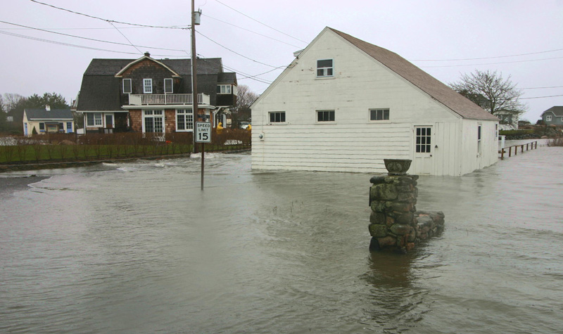
Soundview Road may already be a case in point. (See photo gallery below.) It’s a commercial area that floods, making parts of it inaccessible, and has the prospect of more permanent inundation as the salt marsh around it migrates because of sea level rise.
That could mean moving businesses on Soundview elsewhere. One of them, East River Energy, a fuel supplier that moved there from East Haven three years ago and began major renovations about a year after that, was less than thrilled with that prospect, even if it’s many years away.
A spokesman for East River, a prime supplier of diesel and gasoline to emergency responders, utilities and municipalities, said the company was unaware the coastal resilience plan was in the works.
“What’s disturbing is the town never ever gave anybody any kind of heads up that this was something potentially coming down the pike,” he said, noting that the town had issued them permits for things like above-ground propane storage tanks. “We were spending huge amounts of money.”
The continued existence of about a half-dozen homes that have flooded repeatedly on Neck Road -– an oceanfront stretch accessible only through Madison –- is questioned in the plan.
Seaside Avenue erased?
But, the largest and arguably most startling change being contemplated is Seaside Avenue. About a half-mile long, it runs through salt marsh with homes on both sides, culminating in a spit of higher land. Climate modeling shows it largely underwater by 2080.
With that in mind, the Urban Ecology and Design Laboratory at Yale University, which created some of the long-range landscapes in the plan, envisioned most of the houses removed and the road returning to water, marsh and public beach with a boardwalk connecting the furthermost spit of land to the main part of Guilford.
“I think what it did in terms of our presentation to the public was rather than a doomsday scenario, rather than looking at things negatively and this disaster waiting to happen, we were looking at an opportunity for the town,” said Alexander Felson, director of the lab and an assistant professor in the Yale schools of Forestry and the Environment and Architecture.
He said he worried that homeowners and public officials would still be inclined toward short-term, easier fixes like elevating homes and roads. He advocates big moves that take proactive approaches to future shoreline uses, including reclaiming some of their natural states.
“I think that creative solutions are really essential right now,” he said. “It’s not just more data and more information that’s going to support our choices of how we’re going to move forward, it’s creative thinking outside the box.”
While some residents of the Seaside neighborhood took a wait-for-more-detail approach to such a potentially drastic change, and wondered aloud where the money for such ambitious land alterations would come from, others saw the inevitability of such changes in their own experiences.
Judie Fine’s home at the low point of Seaside Avenue took on a foot of water in Irene — the first water since she bought it in 1991. But she had seen the tides and storm waters growing closer over the years and after nine months of rebuilding, decided if she flooded again she would sell. 
Storm Sandy and 18 inches of water later, she sold to a developer who had been buying up properties on Seaside. (He declined to comment on the resilience plan.) Fine moved 3 miles inland. She viewed her former home on a cold, windy morning in panorama from across the marina, recalling that it had been set on 32 inches of fill.
“It was marsh, sea level is rising,” she said. “I attended the coastal resilience meetings. I believe those maps. I believe that Seaside Avenue will not exist in not too many years.
“Nature is reclaiming what rightfully is hers.”
Her former neighbor, Joseph Nugent, contemplated the home he built 40 years ago on the other side of the Seaside marsh, just off the avenue. “Where I used to have to go 200, 300 feet out to get fiddler crabs,” he said. “I don’t have to. They’re literally in the backyard now.”
Nugent had 4 inches of water in his lower level during Irene. In Sandy, the 300 sandbags he stacked around his foundation kept the water to 10 inches instead of 4 feet.
But he’s had enough, and is planning to sell. After attending the coastal resilience meetings, he favors abandoning the area.
“Some of the properties in this area probably would be best left vacant, be allowed to return to their natural state,” he said. “People that are not willing to accept the concept of tidal change are just going along with blinders on.”
“Better get on board,” he said. “Because the tide is rising.”
[iframe align=”middle” frameborder=”1″ height=”800″ scrolling=”yes” src=”https://s3.amazonaws.com/s3.documentcloud.org/documents/813462/guilford-coastal-resilience-plan.pdf” width=”600″]