


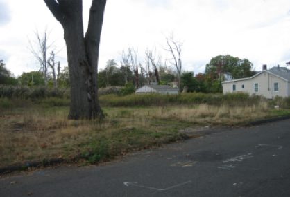
West Haven – There are empty spaces now on Third Avenue Extension along Old Field Creek in West Haven, where cottage-like homes stood as recently as a few years ago.
They stood there in 2011 when Tropical Storm Irene swamped them with floodwaters from Long Island Sound, a block or so away, and when storm Sandy did the same a year later.
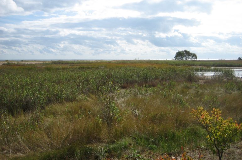
Now, as nature pushes its weedy way back onto these small plots, the shoreline retreat they represent stands as one of the most aggressive responses to the climate change and sea-level rise that are poised to threaten Connecticut’s shoreline even more than thought.
New data from the Connecticut Institute for Resilience and Climate Adaptation (CIRCA) calculates that sea-level rise in Long Island Sound is likely to be 20 inches higher in 2050 than the average sea level used today. And because of that, 100-year floods – those are flooding events with a 1 percent chance of occurring annually – could be eight times more frequent in some shoreline areas.
But six years after Irene, five years after Sandy, and tens of millions of dollars later, West Haven is the exception, not the rule. Connecticut’s shoreline looks much as it did before the storms hit.
Yes, it’s a little stronger. Many homes have been elevated, buildings and infrastructure repaired, and some reinforced. Lots of planning documents have been generated, but implementation of genuine change has been slow. And in the ongoing battle between private property rights and public responsibility, the inclination still largely has been to rebuild structures where they were.
West Haven is proving to be one of the more proactive communities in addressing its shoreline in the face of climate change. And they’re doing it without relying on tight municipal finances.
The city provides something of a study in contrasts with its near-neighbor East Haven, where beachfront properties lay in ruins after Irene. There individual owners have rebuilt and elevated several dozen homes, but the town has little overall resilience strategy.
The two communities are the focus of a recently completed blueprint, Innovative Coastal Resilience Designs, by the Urban Ecology and Design Lab (UEDLAB) at Yale University on behalf of the South Central Regional Council of Governments (SCROG) and funded by CIRCA.
It all made sense
By taking the plunge to allow what essentially are home buyouts – nearly two dozen of them have been completed or are in progress – through a federal floodplain easement program, West Haven did something no other community on the shoreline has.
The easements, which mean properties can never again be developed, are available to properties the government considers slightly less vulnerable than those that are the most flood-prone. The municipality must agree to participate, and the federal government picks up the entire cost.
“It just really looked like an untenable situation long-term to continue to repair these homes and have them flooded out on a semi-regular basis,” said Mark Paine, assistant to the public works commissioner.
Most towns shudder at the notion of losing pricey, tax-generating shoreline property. “We had a neighborhood that was in a state of decline because of the increase in flooding, and we had homeowners that really had no options. Raising their homes was potentially more costly than the value of the property,” Paine said. “It all made sense for us.”
Getting rid of the homes and installing an improved tide gate to moderate flooding at the mouth of Old Field Creek already is resulting in nature-generated improvements to the salt marsh around the creek. It means the marsh should be able to do better what it’s supposed to in storms – hold and purge water. There are now osprey platforms to lure them back to the area.

“There’s nothing like a bird with a five-foot wingspan to generate some public awareness,” Paine joked.
The UEDLAB strategy includes a resilience corridor – a swath that is designed specifically to provide flooding and storm protection – along the Sound that connects with inland wetlands and uses the new train station as the focal point for walkable development.
“It creates a whole neighborhood almost within a park,” said Alex Felson, a Yale professor and landscape architect who runs the lab and has assisted many Connecticut communities with resilience design. “It starts with the expansion of Old Field Creek into a large park area – so it all becomes an amenity.”
There are plans to elevate roads around a new mall and the existing water pollution control plant to protect them from flooding. The plant did not flood during the storms, but road access to it did. The city also is looking at larger, more modern and better-placed sewage outfall pipes and a way to minimize sand migration and increase water flow offshore.
It’s a tall order for any city or town, especially a not-wealthy one like West Haven. The city has a grant writer who has been able to secure funding for projects large and small, including one that helps homeowners with the buyout process and another that provides $3.5 million in federal funds for the road work and dredging of Old Field Creek.
Paine has formed partnerships with Southern Connecticut State University, the University of New Haven and even West Haven High School to help the city with everything from drone mapping and measuring marshes to tide-gate design for the mouth of the Cove River.
“When you don’t have the money to pay for it, you go into education mode,” he said. “We try to really connect the dots with these projects and demonstrate how one affects the other and the amount of leverage the various agencies would get by funding our projects.”
Felson called West Haven “unique,” in terms of its commitment to the need for coastal resilience and its dedication to making it happen in the face of lousy circumstances.
East Haven, he said, is “harder to crack.”
We’re not removing our tax base
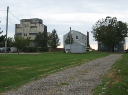
After Irene, East Haven’s prized Cosey Beach was piled with debris where homes had stood. Since then, more than 50 homes have been elevated, so now Cosey Beach Avenue, the street that runs closest and parallel to the water, is a mixture of sky-high homes and old beach cottages still sitting right on the sand.
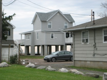
“I guess it’s just a matter of if you have the money and you’re proactive and you want to get up to an elevation,” said Kevin White who is both the town engineer and the director of public works. “But it costs money to do that.”
The road was elevated in 2001 and floods less than it once did, but White said the town has no plans to elevate it again. “We’re dealing with people that own private properties here, and so what we decide is a project may not be what they want to do. I mean I could raise this road up to elevation 11 [feet up]. Their houses are still going to be at elevation six,” he said. “We’re not going to come in here and remove our tax base by buying these properties up and making them open space. That isn’t an option.”
Yale’s Felson doesn’t quite agree. His proposal, which he calls “edgy,” imagines a resilience route — back from the beach and the existing Cosey Beach Avenue. The beach becomes more public and shared parking would be further away from the water in less flood-prone areas. There would be boardwalk access to the beach and the homes on it.
He agrees with White that Cosey Beach Avenue should not be elevated – but for an entirely different reason. “It sends a message to homeowners that it’s OK to be there – that the town is going to take care of you,” he said. His maps of the area show water eventually encroaching well into areas were homes now stand.
The town is considering elevating two small pump stations and addressing persistent flooding from the salt marsh that provides the only access to Silver Sands beach just west of Cosey. But it’s short of funds too and has not been as proactive as West Haven in seeking grants and other financial sources and work-arounds.
White said the town would be willing to put up a small percentage of the cost to match larger federal or state contributions, but prefers to spend the money to clean up after a storm than spend it to NOT have to clean up.
“That’s correct,” he said. “Other than maintaining on a weekly or monthly basis, we have no long-term plans that the town is looking at unless we’re participating with the state or the federal government.”
Sandy funds
There is money out there, and Connecticut has snagged a chunk of it. Not the kind of money New York and New Jersey got after Sandy – but not chump change either.
That state received more than $159 million from the federal government in the form of Community Development Block Grant Disaster Recovery funds after Sandy. Most of it went to housing, but nearly a quarter of it went to infrastructure projects in 11 municipalities, most of which have yet to be started, let alone completed. They include on-shore drainage improvements, offshore resilience repairs and improvements such as bulkheads, erosion controls and even generator upgrades.
Bridgeport and New Haven also received a combined $60 million – a comparatively small amount – as part of two disaster recovery competitions. They too are a long way from completion. They are still in the planning stages for massive remedial work, including a berm and road elevations in Bridgeport. The goal of both projects is to mitigate flooding on the immediate coastline.
David Kooris was Bridgeport’s director of planning and economic development when the storms hit. Now he’s the point person in the state Department of Housing overseeing implementation of the two competitive awards as well as coordinating State Agencies for Resilience (SAFR, pronounced safer), an inter-agency climate resilience strategy.
He’s seen first-hand what happens when low-lying poor neighborhoods meet a tropical weather system. But in places like that, he warns that resilience is more than a seawall or an elevated house, and that recognition can mean more money.
“When we look at resilience in the community – we’re thinking certainly about the acute shocks like hurricanes but we’re also thinking about the chronic stresses,” he said. “In these communities that hampers their ability to respond to the acute shocks.”
He’s talking about chronic poverty, lack of economic opportunity and the need for affordable transportation and housing among other things. Getting those, and everything from jobs to a decent grocery store, better prepares the community when that acute shock occurs.
Such projects can be built to make communities less vulnerable to flooding but also to help them recover once a storm occurs. And they can bring in non-flood-related funding sources that help finance the improvements.
So in Bridgeport, for example, the projects are primarily designed to reduce flood risk, but they’ll also better connect downtown to the waterfront. They’ll create neighborhood open spaces, the foundation for affordable housing and more. “Because of those multiple benefits, that opens you up to a broader stream of potential funding sources,” Kooris said.
CIRCA has provided more than $750,000 for 17 grants for planning and other resilience work. Cities and towns that have made the effort also have been able to cobble together other grants.

What’s going to happen in 20 years is a big deal
According to research by Bill Rath, a legal research fellow at the Center for Energy and Environmental Law at UConn Law School, the state is among fewer than a handful of the 23 oceanfront states in the U.S. that require consideration of sea-level rise in planning processes such as Connecticut’s state and municipal plans of conservation and development and hazard mitigation plans.
But it’s just consideration – communities don’t have to heed it. At least seven other states, including Massachusetts and Rhode Island, have stronger statutes that require incorporating sea level rise into at least some decisions.
Rath’s research also showed that among Connecticut’s two-dozen shoreline municipalities, 10 require that new or substantially rebuilt residences in flood zones only meet the basic elevation standards dictated by the National Flood Insurance Program. Only one, New London, requires elevation two feet above that base flood elevation (BFE). Most of the rest require a foot above.
“I don’t think there’s a chance that BFE is enough. If I was building my own coastal home today, I would go BFE plus two (feet),” said Joe MacDougald, who runs the Center and has served in planning and zoning in the shoreline town of Madison. “Nothing about this ever says, ‘Oh, it’s not as bad.’ There’s never been anything I’ve read that says, ‘don’t worry.’”
He said municipalities have the authority to increase elevation requirements – the question is how to get them to do it as well as make other resiliency changes. “They need a wake-up call to understand that it’s bigger and worse than they’re expecting. They need to get themselves onto a storm footing,” he said. “We now understand what’s going to happen in 20 years is a big deal. The structures they are approving today are the ones that will be affected.”
Guilford is among communities that have been active on shoreline resilience.
The town has adopted a radical resilience plan that would eventually remove homes from certain low-lying areas and allow those spaces to return to nature. But so far the town has only managed to elevate a few roads. Green infrastructure and living shoreline projects, which more naturally handle drainage and disperse higher water levels and wave action, are planned. A critical state road that runs through low-lying areas and salt marsh in Guilford and Branford and habitually floods is being considered by the state for remediation – but with finances what they are, that could continue to lag.
Potentially, the most ambitious resilience idea is the state’s first regional resilience framework – a comprehensive strategy covering 10 communities from Fairfield to Madison, prepared by the Nature Conservancy and the two councils of government that correspond to the area. It focuses on projects — everything from dune and marsh restoration to beach reconfigurations, road elevations and re-routing, barrier fortification and drainage control — that chief author Adam Whelchel, director of science for the Conservancy’s Connecticut office, said are a high priority but have no funding. The goal he said is to develop solutions, not just react to problems.
Then it’s up to the towns. “We can tee it all up,” he said. “If there’s not that reliance on themselves and not taking advantage of the setup, they can’t say they didn’t know. They just need to take action.”
Regional efforts could provide the best paths forward for towns that don’t have the money or expertise to do their own plans. The Nature Conservancy also developed a Resilience Guidebook for the southeastern area of the state.
Felson said that local plans – like the kind he’s done for East and West Haven and elsewhere, are valuable in that many can be scaled up. “A lot of this is laying the groundwork for these changes,” he said of the generally slow pace.
“My concern is that there are choices and actions that are taking place that are bad choices.”
“The learning process is like a slow burn,” Felson said. “The infusion of education and smart thinking is something that’s taking time.”