


This is the first in an ongoing series of stories that will examine environmental and climate issues affecting the Connecticut shoreline.
It was exactly the 2013 hurricane forecast no one wanted to hear: An active to extremely active Atlantic season, according to the National Hurricane Center. Specifically – a 70 percent chance of 13 to 20 named storms including seven to 11 hurricanes, three to six of which could be major.
“I’m hoping they’re just wrong,” said Brian Thompson, director of the Office of Long Island Sound Programs at the Department of Energy and Environmental Protection. “But I’m not going count on that.”
Preparing for the potential while keeping in mind the vulnerabilities exposed during the last two hurricane seasons that brought us Irene and Sandy (not to mention the last two winter storm seasons) is under way here and in other affected states.
But one critical –- and deadly — issue has proved gnarly for forecasters and planners: storm surge.
“As a nation we don’t understand storm surge well, nor do coastal communities understand storm surge risk,” said Jamie Rhome, a storm surge specialist at the Hurricane Center. “It’s one of the hardest things to communicate.”
The center describes storm surge as “an abnormal rise of water generated by a storm, over and above the predicted astronomical tides.” Throw the tides in and certain other conditions and the result can be devastating flooding that travels miles and miles from shore.
“People don’t understand how far inland storm surge can go,” Rhome said. “It penetrates well inland, goes up rivers, into bays. It goes wherever it can, and people don’t realize they are at threat of flooding.”
Data from Superstorm Sandy compiled by the FEMA Modeling Task Force and mapped by UConn’s Center for Land Use Education and Research show storm surge went up the Connecticut River nearly to Middletown; made it up the Housatonic River to Shelton, Derby and Ansonia; overspread places like Fairfield, Bridgeport, Milford and East Haven; and generally thrust into rivers, streams, marshes and other low-lying areas along the entire coast.
But many people still think of storm surge as a wave or a short-lived event and don’t realize that three-quarters of the deaths in hurricanes are caused by drowning, most of which likely are the result of storm surge. 
“It’s our No. 1 concern. We know that it kills people, and people don’t seem to understand their own vulnerability. We’ve shown that over and over,” said Betty Morrow a sociologist and professor emeritus at Florida International University. She worked with ERG Inc. to do polling and analysis on storm surge for the Hurricane Center.
She said people know storm categories very well. But she pointed out, categories are based on wind. Water is another matter.
“You can’t stand up in a foot of rushing water,” she said. “People thought they would have time to leave if they waited to see how bad it was.
“We see people who are in very low elevations and very vulnerable and say, ‘How concerned are you about storm surge?’ And they say, ‘Oh, not concerned.’”
So the Hurricane Center is trying a new approach. Aside from talking about storm surge with any reporter who asks, it’s rolling out a new warning map for a test run in Florida, assuming the situation arises. Devised with the help of social scientists and communications experts, including those at ERG, it is color-coded green, yellow and red for the surge risk a specific storm poses. The Center plans to release it real-time as a storm heads for land. And it’s designed to be understood by weather experts, media and emergency officials as well as the public. 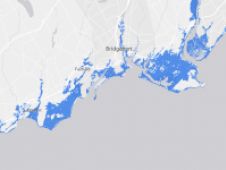
“We would be using those products and pushing those prods out once they are finalized,” said Scott DeVico, a spokesman for the Connecticut Emergency Management and Homeland Security Division of the Department of Emergency Services and Public Protection.
During storms Sandy and Irene, Rhome was in frequent communication with Connecticut Emergency Management Director William Hackett. But DeVico pointed out that storm surge and other updates are passed on to municipalities and it’s up to them to make the calls on evacuations and other measures.
“We have said at the department and the governor has said over and over again, heed the warnings of your local safety officials. If you’re told to evacuate -– you should evacuate.”
Easier said than done.
It turns out people typically base the assessment of their vulnerability during a storm on how they fared previously. That’s exactly the wrong paradigm, said Rhome and other experts. Because many factors figure into storm surge projections, storms of the same category can have enough different features to make their impacts vary widely. Having survived one storm is no assurance of surviving another. 
The biggest variables are the intensity of the storm itself, its track, its travel speed, its wind speed, the size of its wind field, its angle of approach, the characteristics of the landfall location and timing -– especially in relation to the tide cycle.
For example, a storm hitting Connecticut from the south may have the benefit of having Long Island act as a buffer, something Sandy did not have. Mostly Sandy hit a bit off high tide, which helped. But if a storm hits in a highly developed area, the impact of storm surge is likely to be amplified.
Compounding that are the effects of sea level rise, which mean the base water level is now higher than it used be, so there’s more water available. And the impact of coastal changes, natural ones from long-term erosion and previous storms as well as man-made ones such as additional building and coastal armoring like seawalls, means storms similar to ones in previous years can have different effects -– likely worse ones, experts said.
“This is why forecasting surge is so tricky,” Rhome said. “Everyone wants to talk about how Sandy merged with a winter storm, and sometimes we’re missing the most critical factors: landfall location and the timing of high tides.”
The Hurricane Center also plans to present storm surge in terms of its height, rather than its depth. A seemingly semantic change they hope will make a large difference.
“Usually if person can see ocean from their home, we have a fighting chance that they will understand,” said Rhome of storm surge warnings. “So few people know whether they live in an evacuation zone, yet it is the single most important thing one could know.”
His advice: “Just take five minutes to see if you’re in an evacuation zone.”