


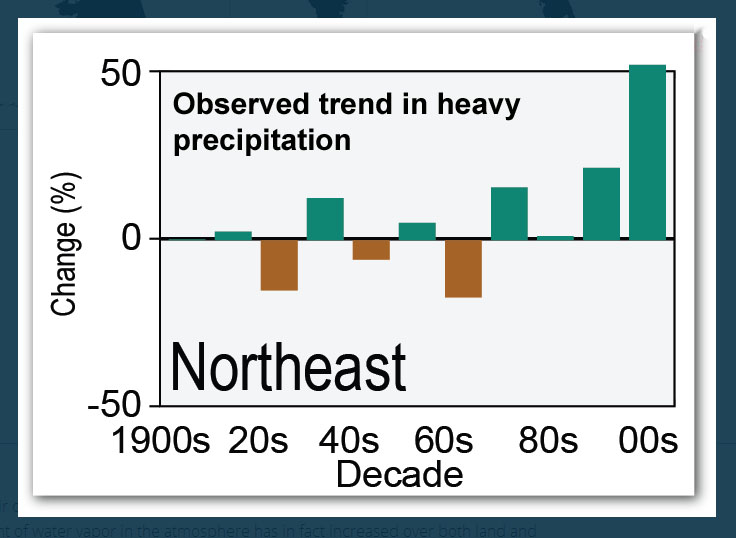
It’s no secret that the Northeast is experiencing dramatic increases in the number of extreme storms — and more precipitation from those storms.
The change has been well documented, most recently by the National Climate Assessment, released in May, that showed a 71 percent increase since 1958 in the amount of precipitation in the heaviest one percent of precipitation events in the Northeast.
More rain isn’t necessarily a bad thing, but Connecticut may be ill-equipped to handle all that extra water. Due to the ongoing use of badly outdated data, much of the drainage installed in Connecticut in the last several decades may prove to be too small to handle today’s rainwater volumes.
“We’re using very, very old data to design our infrastructure on,” said Art DeGaetano, director of the Northeast Regional Climate Center housed at Cornell University. “An update was long overdue particularly with climate change.”
Indeed, with rainfall on the upswing, using out-dated design can mean inadequate drainage systems, and there’s a cascade effect from water that’s unable to drain.
Aside from the initial flooding that can drown crops, destroy bridges, make roads impassable, and leave basements a horror show, poorly drained runoff can erode the land and weaken whatever structures are on it, including roads and buildings.
Few cities and towns are aware that far more accurate and up-to-date rainfall information is already available — and more is due in the next year or so. And even for those who are aware, there is neither the money nor governmental authority to take advantage of the information.
In 1961 the National Oceanic and Atmospheric Administration – NOAA (which provides the NRCC with most of its funding) – crunched national rainfall records ending in the 1950s and set standards for rainfall in what would be known as the 100-year storm, the 50-year storm and so on. It’s been the industry standard since.
Over the years, governmental entities like the Connecticut Department of Transportation have used those standards to build roads and bridges with drainage pipes and culverts sized to handle those levels of rainstorm runoff.
In the mid 1990s, a group of Connecticut officials and experts, concerned that the 1961 rainfall levels were too old, came together to try to update them and to potentially standardize their use. They asked Cornell to run new numbers, which it did, showing an increase in water volume even then. But those numbers were never put into general use.
In 2008, the NRCC compiled updated statistics for New England and New York. Released in 2010, they showed Connecticut with a 15- to 25-percent increase in rainfall from extreme storms over the 1961 levels. Other parts of the region were even higher.
“When I started to see the Cornell data, it became clear how drastically this stuff had changed for the large events,” said Michael Dietz, director of the University of Connecticut’s Nonpoint Education for Municipal Officials program, or NEMO. “For Groton for example, what used to be the 100-year storm is now the 50-year storm. That’s striking.”
Even so, the 1961 data is still the Connecticut standard for the most part and that’s partly because when it comes to drainage regulation in Connecticut, no one is in charge.
“There really isn’t one standard,” said Art Christian, an engineer with the inland waters group at the Connecticut Department of Energy and Environmental Protection. His interest in rainfall data largely involves its impact on dam safety specifications for thousands of dams in the state. He not only calls the old rainfall data archaic, but also calls the engineering philosophies for drainage out of date.
The Department of Transportation uses the data from NOAA, which, to be fair, is being updated with an expected release in September 2015. It will include another six years of data spanning the two major tropical storms Irene and Sandy.
The Natural Resources Conservation Service, an arm of the U.S. Department of Agriculture, which requested the New England and New York 2008 data update from Cornell, activated those results two years ago for its farming and environmental projects including watershed planning and stormwater management.
But Connecticut cities and towns are free to do what they want. There’s no state standard the way there is for a building code, for example. Many cities and towns adopt the DOT standards, which means they’re still using rainfall levels from 1961.
Some communities write their own code and some just work on a project-by-project basis.
There’s also no uniformity to how whatever standards are being used are then applied. For instance, the DOT has a system for when the 100-year storm levels apply – mainly huge bridges; and when the 50-year, 25 and 10-year storms apply.
But as for cities and towns: one could apply the 10-year storm to everything; the next town over could use 100-year levels, and the next town could use a mix.
Could drainage standards be codified for the state? “I think certainly it would help,” said Christian. “But where would that live? Who would have that authority? There’s no agency that regulates volumes of water.”
The level of awareness of the new storm data for drainage purposes varies from town to town, but some changes based on them are underway. The DOT is aware of the NOAA update coming in a year as well as the updated numbers from Cornell. Recognizing that its drainage standards will change as soon as NOAA’s numbers become official, the DOT began a pilot study 18 months ago to see how some of its current drainage would fare against Cornell’s new numbers.
“We’re trying to assess what are my risks as an infrastructure,” said Tom Harley, the DOT’s chief engineer.
Using $125,000 from a Federal Highway Administration grant and matching funds from the state, the study is looking at the drainage around 179 medium-size bridges in Litchfield County.
Even so, for ongoing work, Harley said: “We’re still using the old numbers, but we’re applying some logic. We know the new numbers are out there.”
Westbrook, which writes its own drainage codes, was aware of the Cornell numbers when the town’s stormwater regulations were updated a few years ago. So it added general language allowing the town to use “updated extreme precipitation climate data as available.”
“We understood the model everybody was using to design drainage was not adequate,” said Town Planner Meg Parulis.
In Westport, which typically uses the 25-year storm as its benchmark for drainage, Town Engineer Peter Ratkiewich said he was not ready to jump to new standards.
“When the modification of the data becomes widespread knowledge, then we will update,” he said. “We’re not going to rip up the storm drains.”
That’s an important point on several levels. First of all no municipality or the state has the kind of money needed to retrofit all the undersized pipes and drainage apparatus.
There’s potential danger if they did. Because drainage systems are interconnected, larger pipes and other mechanisms to carry greater amounts of water can cause problems like erosion and water backups when connected to narrower ones downstream.
Making matters worse is a cost-saving way many towns use to repair culverts – re-sleeving. It adds another layer to the inside of the pipe, making it narrower and less able to move water. And for shoreline towns, sea level rise is taxing drainage doubly with water that comes up more often, sticks around longer and saturates more areas leaving them unable to soak up additional water.
NEMO Director Dietz said these conditions and many more make his message to cities and towns all the more important.
“This is happening. There’s no debate about what this trend is. You can debate all you want about the causes of it, but these are the facts,” he said he tells communities. “How are you going to deal with it? Is your infrastructure big enough to handle this? Is it currently being overwhelmed and how are you planning for the future?
Low impact development, called LID for short, and green infrastructure are partial solutions Dietz said. They include techniques like rain garden and bio-retention systems that can soak up water, permeable paving that also allows water to sink into the ground rather than run off, green roofs and water harvesting for other purposes.
“You’re definitely not going to retain the whole 100-year event,” he said. “The goal is to just retain some portion of it so that it takes the pressure off.”
The first step he said is to get some sense of where the existing problems are. Then he said, look at the new data.
“Anybody in this state that’s going to be designing any sort of new system needs to be in line with these newer guidelines,” he said. “Using the updated precip data is, I don’t know, it’s just like a no-brainer in my opinion.”