


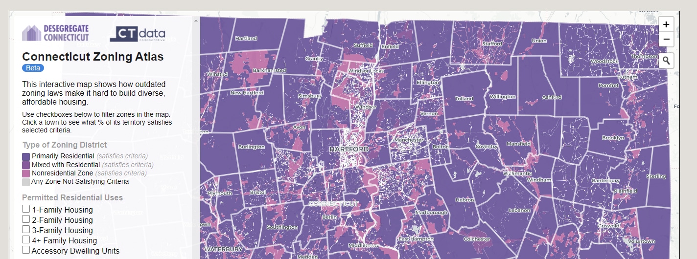
Recently a coalition of zoning reform advocates, DesegregateCT, released the first interactive map in the country to document how all zoning districts in a single state treat housing. The groundbreaking Connecticut Zoning Atlas is likely to be one of the most important tools for planning our communities our state has ever seen.

Zoning is important, because it affects all of our lives. Through zoning, public officials decide where you can live, open a business, or even grab a cup of coffee before work. Yet while the impact of zoning is clear, for most people, reading the zoning code itself is not. According to law professor and architect Sara Bronin, who led the research team for the Zoning Atlas, the average length of zoning text in our state is 180 pages, and several zoning codes were not even available online. Most of these codes are filled with planning terms and can even sometimes be difficult for attorneys and planners to interpret.
The Zoning Atlas helps people see how their town treats housing, without having to sift through the zoning codes themselves. It clearly depicts how local zoning regulations allow or restrict different housing types across the state. The data can be viewed on a town-by-town basis or at a regional and statewide level. Given the number of different zoning districts across the state (more than 2,600) and the lack of a central clearinghouse for local zoning information, the new Atlas provides unique insights for anyone interested in housing policy and in creating more sustainable and equitable communities.
The members of the organization I lead, the Connecticut Chapter of the American Planning Association, hopes that state legislators, local land-use officials, and residents will use the Zoning Atlas to answer some critical questions. Does your community allow duplexes, three- and four-or-more family units?
Does it encourage walkable neighborhoods, and neighborhoods centered around public transit? Does your zoning permit accessory dwelling units, an important economic tool for both homeowners and renters alike, without a public hearing? Comparing your community to others around the state – how, and more importantly, why, is it different? And together, we should all consider the impacts of limited housing diversity on Connecticut’s economic and social future.
It is important to acknowledge the depth of research that went into this effort. Bronin and her volunteer team painstakingly collected about 70 different housing-related characteristics for each zoning code. They confirmed its accuracy in several ways, including by asking town planners to review it. Cary Chadwick, a geospatial educator, led the effort to collect GIS layers showing zoning districts. In some cases, particularly after finding a few hand-drawn town zoning maps, she ended up digitizing the zoning districts herself. The Connecticut Data Collaborative put the code research and maps together into an impressive and easy-to-use public interface.
Sound planning connects data analysis with consensus building around a vision for a more affordable Connecticut. Take a look for yourself at https://www.desegregatect.org/atlas and start a conversation in your community. Together, let’s use this new information to help build a more inclusive and sustainable Connecticut.
Rebecca Augur, AICP, is President of the Connecticut Chapter of the American Planning Association.